
Toronto, Canada – TheNewswire - May 13, 2021 - Mammoth Resources Corp. (TSXV:MTH), (OTC:MMMRF), (the “Company”, or “Mammoth”) is pleased to provide an update on its drill targeting activities, the combination of results from the recently announced initial 2.4 kilometres (km) of the 3-dimensional (3D) drill target modelling from its infill, Induced Polarization/Magnetometer (IP/Mag) geophysical survey recently completed at its 100% owned Tenoriba gold-silver property located in the prolific Sierra Madre precious metal belt, Mexico.
This 3D modelling shows drill target opportunities in at least 4 areas (TA-1 to TA-4) plus enhanced areas (TA-3(a) and (b)) within larger target areas. These target areas suggest attractive geophysical features at depths of up to 200 metres (m) and often occur within, and along trend from gold-silver mineralized intervals in prior drilling and coincides with surface gold-silver mineralization in over 3,000 combined soil and rock chip and channel samples. These target areas extend over 100’s of metres (TA-4) potentially up to the full 2.4 km of the surveyed and modelled interval (TA-3).
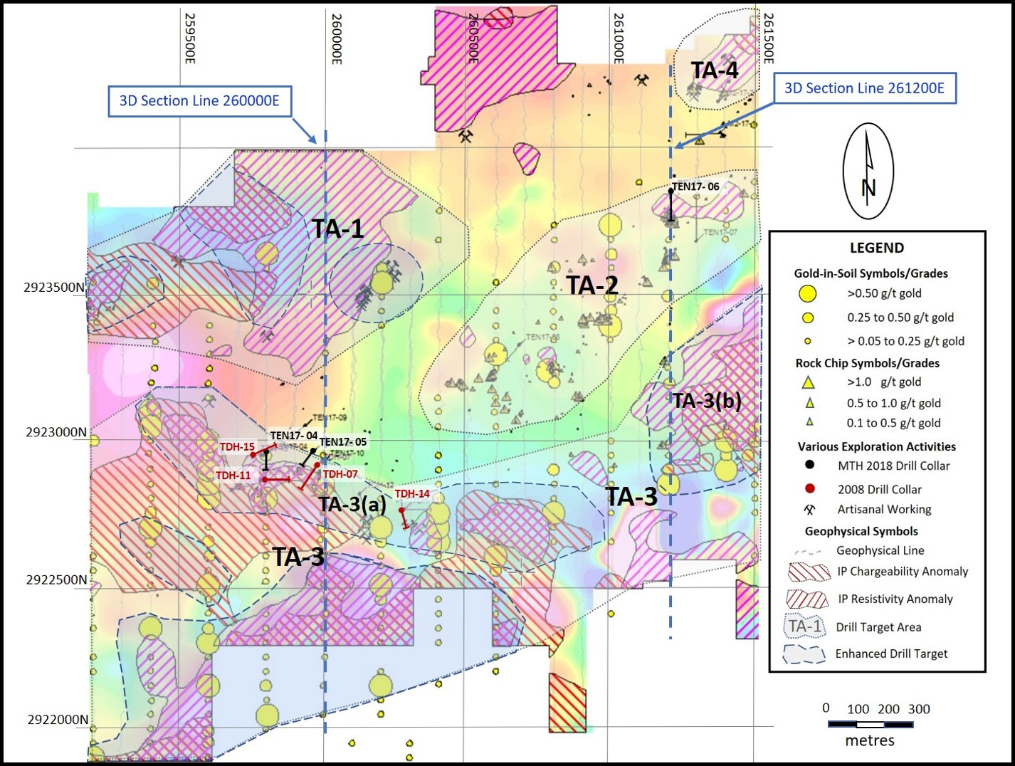
For the location of these target areas please refer to Figure 1 – “Location Map - Drill Target Areas, Tenoriba Project (over Magnetic geophysics colour contouring - 50 metre survey depth).” wherein the combination of anomalously high IP-geophysical resistivity (anomalously high resistivity areas cross hatched), chargeability (anomalously high chargeability areas cross hatched) and low magnetic geophysical features (colour contoured base map, green-blue is low magnetic) are observed from the recent infill geophysics program, in combination with anomalous gold in soil, rock chip and drill hole intervals (please refer to the General Description of Target Areas, below in this press release wherein the indications of these geophysical characteristics are discussed in the context of their application to the hydrothermal system at Tenoriba and other gold-silver mineralized features).
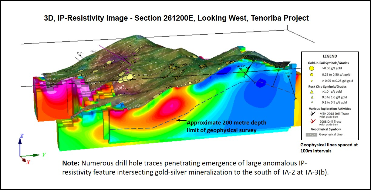
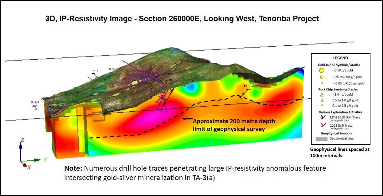
To view illustrative cross sections cutting two of these target areas, please refer to Figure 2 – “Illustrative 3D, IP - Resistivity Image - Section 261200E, Looking West, Tenoriba Project.” and Figure 3 – “Illustrative 3D, IP - Resistivity Image - Section 260000E, Looking West, Tenoriba Project.” wherein the combination of gold-silver mineralization can be seen in the surface imaging in relation to the geophysical features at depth. These sections were selected as they are areas in which prior drilling intersected potentially economical drill intervals and upon which from Figure 1 the lateral extent of these geophysical features are traced. The lateral extent of these features can also be seen in the animated passage through the 3D modelling showing IP-chargeability features coincident with anomalous gold-in-soil results (refer to the Company’s website: http://www.mammothresources.ca/i/maps_figures/2021-04-22-MTH-View-From-SE.GIF. to view this animation passing east to west, and http://www.mammothresources.ca/i/maps_figures/2021-04-22-MTH-SW2.gif. to view this animation passing south to north (also in the “Projects” section “Maps, Images and Photographs” section, dated April 22, 2021 on the Company website).
Thomas Atkins, President and CEO of Mammoth commented on the drill target areas identified from this 3D modelling, stating: "We're very pleased to see such a compelling combination of so many coincident indications of mineral potential in the numerous, extensive trends we see over this initial 2.4 kilometres of 3D drill target modelling. Within this initial 2.4 kilometres alone we've identified four significant trends stretching from hundreds of metres in one instance, to the entire 2.4 kilometres in another. What’s more, a number of these areas remain open to the east and west along the trend of mineralization in areas where we're only now completing our 3D modelling of the same, recently completed infill geophysical survey.
"It’s impossible to show 3D modelling in a 2D press release. However, from the work we’ve performed it's apparent in all of the target areas identified we have a strong correlation between elevated chargeability and resistivity geophysical features often combined or adjacent to low magnetic geophysical features. The high chargeability and resistivity features tend to point to areas of potential mineralizing hydrothermal activity, while the low magnetic features point to areas of potential depletion of magnetic minerals a result of hydrothermal destruction by the heat source responsible for the mineralizing system at Tenoriba. These geophysical characteristics are made even more compelling where, in two areas prior drilling intersected potentially economical gold-silver grades over tens of metres, and these target areas remain open along trend where an abundance of surface gold-silver occurs in soil, chip and channel sampling.
"Next steps in this drill location targeting will be to complete the combined surface, drill and 3D geophysical modelling over the remaining approximate two kilometres of the infill geophysical surveyed area and then to perform this same targeting exercise over this area. From this modelling and target area generative work final drill location selection, for what we hope to be up to a 50-hole diamond drill program, will be assessed in the field for the best accessible drill sites. Mammoth intends to drill these targets with a portable drill rig which facilitates relatively easy drill rig access. Drilling within this 2.4-kilometre area is fully permitted and surface access permits exist for what is expected to be the duration of this initially planned, up to 50-hole program."
Description of Target Areas:
Mammoth is selecting drill targets based on a number of criteria available as a product of its field activities mapping, sampling, performing geophysics and drilling at Tenoriba over a 7 km trend of gold-silver and copper mineralization. The Company is planning to drill up to 50 drill holes in an upcoming exploration program to test target areas over this trend with the intention to specifically spot drill holes following field verification of location and surrounding surface attributes. Initially Mammoth envisages drilling an initial 2 to 4 holes in each target area and upon completion of these initial holes in each area, logging and sampling these holes while another target area is drilled in order to determine the results of these initial 2 to 4 holes prior to returning to further test each individual area. Target areas are defined by a combination of the following features:
- Total of almost 3,000 gold in soil samples covering over 7 km of the mineralized trend - highest grade sample assaying 6.3 grams per tonne (g/t) in soil (refer to press release dated April 15, 2021).
- Surface rock chip and occasional grab samples which total over 750 samples covering an east-west, 6 km trend of surface gold-silver mineralization - highest grade sample assaying 74 g/t gold.
- A total of 151 m along 14 cut surface channels - best interval totalling 13.5 m grading 1.5 g/t gold
- Ubiquitous artisanal mine workings over the 7 km trend of surface mineralization.
- Prior diamond drilling in 26 holes dispersed over approximately 4 km of the surface mineralized trend – refer to Figure 1 - Location Map - Drill Target Areas, Tenoriba Project (over Magnetic geophysics colour contouring), including 25 m grading 4.0 g/t gold equivalent (silver converted to gold whereby 75 g/t silver = 1.0 g/t gold) and 127 m grading 0.5 g/t gold equivalent
- High IP-resistivity areas potentially indicative of presence of highly resistive hydrothermally emplaced silica, including Vuggy silica, high IP-chargeability areas potentially indicative of gold-silver and/or gold-silver mineralizing sulphides and low magnetic areas potentially indicative of heat destruction of magnetic minerals due to the heat source responsible for the hydrothermal the mineralization at Tenoriba.
- Anomalous ISM (Index of Smectite Maturity) samples, wherein the hydrothermal destruction of certain minerals within the rocks at Tenoriba have been altered in such a manner that they have produced certain clay minerals of which various types (dickite, pyrophyllite, alunite) are indicative of high temperature alteration and assist in vectoring to the most active areas of the hydrothermal system at Tenoriba.
Target Area 1:
This target area appears to extend for at least 1 km east-west and open further to the west. This target area is characterized by a combination of:
1)presence of silicified volcanic breccia host rocks,
2)high IP- resistivity and chargeability features,
3)is near a geophysical magnetic low adjacent to magnetic high, potentially indicating proximity to hydrothermal heat source, and
4)numerous gold-silver mineralized artisanal workings.
Target Area 2:
This target area appears to extend for at least 1 km east-west in a northeast-southwest trend and is open to the east. This target area is characterized by a combination of:
1)follow up on successful drilling at TEN 17-06 - 127 m grading 0.52 g/t gold equivalent (including 7.2 g/t silver), which may not have intersected the best geophysical features now evident in this area.
2)Very good surface geology and surface gold-silver samples (rock and soil samples) with presence of silicified volcanic breccia host rocks to the east,
3)high IP-chargeability open to the east and weak but anomalous IP-resistivity geophysical features,
4)is near a geophysical magnetic low adjacent to magnetic high, potentially indicating proximity to hydrothermal heat source, and
5)association with attractive ISM anomalous features further supporting thesis of proximity to hydrothermal heat source.
Target Area 3:
This large target area has the potential to extend for the entire 2.4 km area of modelling and is open to the east and west beyond the modelled area. Within this larger overall trend there appears areas of heightened concentration of attractive attributes, including prior diamond drill results. Broken into its smaller sub-areas, this target area is characterized by:
Area 3(a) extending 1.5 km east-west:
1)Many high grade to highly anomalous prior drill results, including: TDH-07 assaying 4.0 g/t gold equivalent (with 6.8 g/t silver) over 25 m, TDH-11 assaying 0.9 g/t gold over 41 m, TDH-15 assaying 0.7 g/t gold equivalent (with 4.6 g/t silver) over 12 m, TDH-04 assaying 0.8 g/t gold over 18 m, and TEN 17-05 assaying 1.3 g/t gold over 23 m sporadically testing a 500 m interval within this target area and open to the south, east and west,
2)Numerous very high gold in soil samples with sporadic anomalous rock chip samples,
3)high IP- resistivity and chargeability features,
4)follows the north flank of a magnetic low potentially indicating proximity to hydrothermal heat source, and
5)association with attractive ISM anomalous features further supporting thesis of proximity to hydrothermal heat source.
Area 3(b) extending 0.4 km east-west and open to the east:
1)Numerous high gold in soil samples with sporadic anomalous rock chip samples,
2)high IP- resistivity and chargeability geophysical features,
3)combination of magnetic low and high features with IP-resistivity and chargeability indicating proximity to hydrothermal heat source, and
4)associated with attractive ISM anomalous features further supporting thesis of proximity to hydrothermal heat source.
Target Area 4:
This area extends for 0.3 km and is open to the east. It is characterized by numerous artisanal workings and high IP-resistivity and chargeability geophysical features. This area hasn’t undergone as much study as other areas, however the geophysical features remain open to the east and should undergo further evaluation once the geophysical modelling, currently underway, is extended further east.
As part of its first quarter 2021 surface exploration program Mammoth completed detailed confirmation geological mapping and expanded soil sampling with an infill IP/Mag geophysical survey and 3D drill target modelling. The IP/Mag infill geophysical survey is designed to cover most of the 60% of the 6-kilometre trend of surface mineralization not previously covered by the Company’s earlier 2013 IP/Mag survey. This work follows up on activities performed by Centerra Gold during its 21 months on Mammoth’s Tenoriba property (Centerra notified Mammoth it was ceasing its exploration activities in Mexico in September 2020, returning 100% of the Tenoriba property to Mammoth - refer to press release dated September 22, 2020) and based on the recommendations, following a review by PhD geologists Drs. Ressel and Christensen of MDA/RESPEC consulting. The PhD study included a review of all historical data from exploration activities at Tenoriba, including mapping and sampling over 3,000 surface soil and rock samples and 26 drill holes totalling almost 5,000 metres (m) sporadically testing mineralization along 4 km of the 6 km trend of known gold-silver mineralization. The report concluded that “Tenoriba is a high-quality early to mid-stage exploration project with potential to host an economic high-sulfidation epithermal deposit” (refer to press release dated February 18, 2021 and Mammoth’s website: www.mammothresources.ca/s/TechReports.asp.).
A total of 2.4 km of 3D modelling of the geophysical data is now complete. Mammoth is working closely with Intelligent Exploration (IE) geophysicists to model the IP/Mag geophysical characteristics of the rocks in this area employing 3D modelling to integrate a combination of surface and drill data to assist in identifying attractive targets to identify the continuity of surface gold-silver mineralization at depth. IE is a geophysical consultancy of highly experienced PhD and P.Geo geophysicists, with years of experience on a variety of deposit types, employing the most modern geophysical techniques to enhance the geophysical evaluation of mineral deposits.
Qualified Persons:
The IP/Mag survey was conducted by Géophysique TMC (TMC) of Val d’Or Quebec, contracted by Mammoth from TMC’s Mexico office. Chris Hale and John Gilliatt are the principal geophysicists at Intelligent Exploration. Dr. Chris Hale holds a BSc in Earth and Planetary Sciences from Erindale College, University of Toronto, a MA from the University of California and a PhD from the University of Toronto and has 45 years of mineral exploration experience. John Gilliatt holds a BSc in Geophysics from the University of Alberta and is registered as a P.Geoph. (Alberta) and has over 30 years of mineral exploration experience. Both partners hold P.Geo. registration in Ontario and are members of the Canadian Exploration Geophysical Society (KEGS). IE provides consulting services under a Certificate of Authorization from the APGO (Association of Professional Geoscientists of Ontario).
About Mammoth Resources:
Mammoth Resources (TSX-V: MTH) is a precious metal mineral exploration Company focused on acquiring and defining precious metal resources in Mexico and other attractive mining friendly jurisdictions in the Americas. The Company holds a 100% interest (subject to a 2% net smelter royalty purchasable anytime within two years from commencement of commercial production for US$1.5 million) in the 5,333 hectare Tenoriba gold property located in the Sierra Madre Precious Metal Belt in southwestern Chihuahua State, Mexico. Mammoth is seeking other opportunities to option exploration projects in the Americas on properties it deems to host above average potential for economic concentrations of precious metals mineralization.
To find out more about Mammoth Resources and to sign up to receive future press releases, please visit the company's website at: www.mammothresources.ca., or contact Thomas Atkins, President and CEO at: 416 509-4326.
Neither the TSX Venture Exchange nor its Regulation Services Provider (as that term is defined in the policies of the TSX Venture Exchange) accepts responsibility for the adequacy or accuracy of this release.
Forward Looking Information: This news release may contain or refer to forward-looking information. All information other than statements of historical fact that address activities, events or developments that the Company believes, expects or anticipates will or may occur in the future are forward-looking statements; examples include the listing of its shares on a stock exchange and establishing mineral resources. These forward-looking statements are subject to a variety of risks and uncertainties beyond the Company's ability to control or predict that may cause actual events or results to differ materially from those discussed in such forward-looking statements. Any forward-looking statement speaks only as of the date on which it is made and, except as may be required by applicable securities laws, the Company disclaims any intent or obligation to update any forward-looking statement, whether as a result of new information, future events or results or otherwise. Although the Company believes that the assumptions inherent in the forward-looking statements are reasonable, forward-looking statements are not guarantees of future performance and, accordingly, undue reliance should not be placed on these forward-looking statements due to the inherent uncertainty therein.
Figure 1 - Location Map - Drill Target Areas, Tenoriba Project (over Magnetic geophysics colour contouring - 50 metre survey depth)
Click Image To View Full Size
Figure 2 - Illustrative 3D, IP - Resistivity Image - Section 261200E, Looking West, Tenoriba Project.
Click Image To View Full Size
Figure 3 - Illustrative 3D, IP - Resistivity Image - Section 260000E, Looking West, Tenoriba Project.
Click Image To View Full Size
Copyright (c) 2021 TheNewswire - All rights reserved.
